Page 1 of 1
Maps
Posted: Mon Dec 05, 2022 4:44 am
by gurusql
High Level Map of the Jotens Area
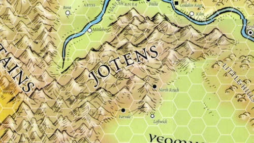
- Jotens01.jpg (149.54 KiB) Viewed 564 times
30 miles per hex (This should be considered a good approximation)
Plans known to the Players
Re: Maps
Posted: Mon Dec 05, 2022 4:45 am
by gurusql
Re: Maps
Posted: Mon Feb 20, 2023 10:39 pm
by gurusql
Here are the directions from Loftwick (the capital) to Silver Spring
Exit Loftwick from the east gates and take the New Road (with the High Crags on your left) for about 10 miles.
At the first branch, take the northern road (again with the High Crags on your left) eventually you will reach Emberton, it is about 25 miles.
Exit Emberton from the north side of the city and after about 35 miles you will reach the North Reach. North Reach is the last town in the Yeomanry League. Recommend you stay away from the sewars. With hard riding and pushing your horses you can reach this in one day, but it will be several hours after dark when you get there.
You find a wide trail out of the North Reach to the north that will go for about 60 miles into the Jotens. The trail will head toward the northwest and it should take about 2 1/2 days to reach these cross roads since you will be much slower in the mountains. At that point the trail will have an intersection of four trails. You will want to take the trail that heads the most to the east.
Take this trail for about 65 miles to get to Silver Spring which should take another 2 1/2 days.
Re: Maps
Posted: Sun Nov 12, 2023 3:02 am
by gurusql
gurusql wrote: ↑Sun Nov 05, 2023 6:44 pm
In the Jotens - Mid-day - The Meeting
Sunday, 16th day of Planting, 597
11th day since leaving Loftwick
We can offer you food and map. The SS refers to Silver Spring and it shows the primary branches off the highway. Please note that where the 'I' is on the map is the entrance to a series of caves that the illithids have taken over the far side. The darker colors are primary branches off the Highway that we are recommending that you avoid."[/dialog]
Highway Map